
Lee strengthened from a tropical storm into a hurricane Wednesday and is forecast to become an “extremely dangerous major hurricane” by Friday, forecasters at the National Hurricane Center said.
Here’s what to know about the storm, where it may be headed, and when it will become a hurricane.
When did Lee become a hurricane?
The National Hurricane Center said in an update shared at 5 p.m. ET on Wednesday that Tropical Storm Lee had strengthened into a Category 1 hurricane. As of late Wednesday night, the storm had maximum sustained winds of about 80 miles per hour and was continuing to strengthen.
The storm is expected to become a “major hurricane” by Friday, the NHC said, as the storm intensifies at a “steady to rapid” pace. It may become a Category 4 hurricane — a potentially “catastrophic” storm with sustained wind speeds of 130-156 mph — as it travels over very warm water.

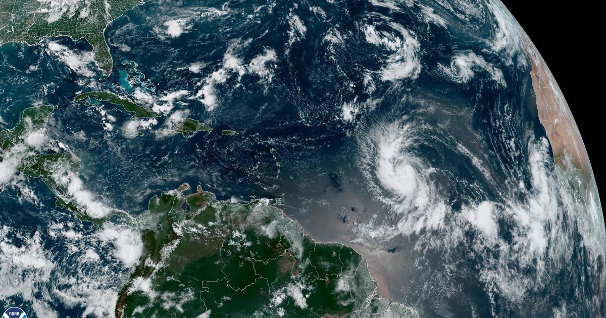
NOAA GOES Image Viewer
Where is Hurricane Lee heading?
The storm is moving west-northwest at about 14 miles per hour, the NHC said Wednesday night. This path is expected to continue, the center said, with a “slight reduction in forward speed over the weekend.”
Hurricane Lee is expected to pass near the northern Leeward Islands and Puerto Rico this weekend. The Leeward Islands are a group of islands located where the Caribbean Sea meets the western Atlantic Ocean, and include the U.S. Virgin Islands.
Large ocean swells are expected to reach the Lesser Antilles by Friday, and then the U.S. and British Virgin Islands, Puerto Rico, the Bahamas, Bermuda and Hispaniola by the weekend, the hurricane center said.
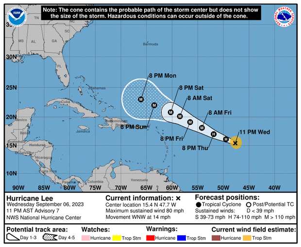
NOAA/National Weather Service
Its center was about 1,035 miles east of the northern Leeward Islands as of Wednesday night. The Leeward Islands includes the Virgin Islands, Anguilla, Saint Martin and Saint Kitts.
There are no coastal warnings or watches in effect at this time, the hurricane center said, but “interests in the Leeward Islands should monitor the progress of Lee.”
“The most probable scenario is that Lee will track far enough north to bring just a brush of gusty winds and showers to the northern Leeward Islands,” The Weather Channel reported. But it adds, “we can’t fully rule out a more southern track that takes Lee closer or directly through the islands with more serious impacts.”
The longer range forecast is uncertain, but meteorologists will be watching to see if Lee starts steering towards the U.S. mainland or remains on a path over open ocean.
Is Hurricane Lee going to hit Florida?
Hurricane Lee is not forecast to impact the United States at this time, CBS Miami reported. CBS Miami chief meteorologist and hurricane specialist Ivan Cabrera Lee said the storm system is expected to turn to the north and away from the U.S. coast, but weather experts will continue to monitor its progress and track it closely.
Florida is currently recovering from Hurricane Idalia, which made landfall along the Gulf Coast last Wednesday and left a trail of damage across the Big Bend region — the area where the Florida peninsula meets the panhandle. The storm caused severe flooding in Florida and other states including Georgia, South Carolina and North Carolina, before moving out to sea. Several deaths have been attributed to the storm, and the financial toll of the hurricane could reach $20 billion, CBS News previously reported.
Hurricane Lee spaghetti models
Spaghetti weather models, or spaghetti plots, are computer models showing the possible paths a storm may take as it develops. These models don’t predict the impact or when a storm may hit, according to the Weather Channel, but focus on showing which areas might potentially be at risk.
Spaghetti models for Hurricane Lee mostly show the storm traveling over the ocean. Some paths might take the storm close to the Leeward Islands. A recent spaghetti model for Lee created at 6 a.m. ET Wednesday shows most projected paths curving northward and remaining out over the open Atlantic, but a few veer more to the west for a potential impact in the islands or along the U.S. Mid-Atlantic or New England coast next week.
CBS New York reports the forecast models have been going back and forth on the track of the storm — on Sunday night they were suggesting a landfall in the Mid-Atlantic region, then on Monday, going out to sea. As of Wednesday, the track is much closer to the East Coast. The ECMWF, or European model, has Lee staying out to sea, and not making a direct landfall, but coming very close to the U.S. mainland. Meanwhile, the GFS, or American model, has Lee scraping Cape Cod, and then heading into the Canadian Maritimes.
Meteorologists expect to get a clearer picture of the storm’s likely path as it continues to develop in the coming days.


