
Hurricane Lee, now a Category 2 storm churning in the Atlantic, is expected to rapidly intensify into an “extremely dangerous major hurricane” by early Friday, the National Hurricane Center says.
Large ocean swells are expected to reach the Lesser Antilles by Friday and the U.S. and British Virgin Islands, Puerto Rico, the Bahamas, Bermuda and Hispaniola by the weekend, the hurricane center said.
“These swells are likely to cause life-threatening surf and rip current conditions,” the agency reported.
Forecasters say it’s too soon to project the extent of the hurricane’s potential impact, but for now the Leeward Islands, where the Caribbean and Atlantic meet, should stay alert. The Leewards include the Virgin Islands, Anguilla, Saint Martin and Saint Kitts.

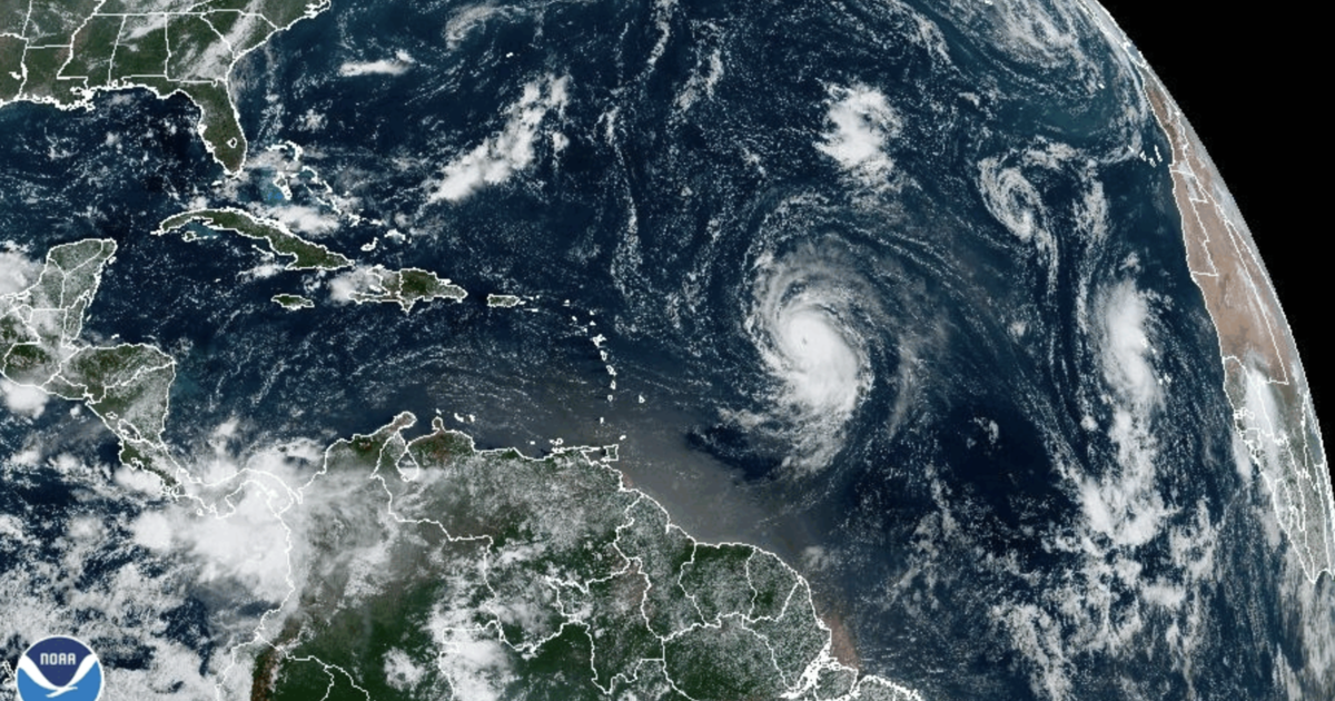
NOAA / National Weather Service
Just before 11 a.m. ET on Thursday, Lee was traveling west-northwest at 15 mph over the southern Atlantic Ocean, with maximum sustained winds of 105 mph — a 25-mph jump from its recorded maximum wind speed six hours earlier, with higher gusts. Its center was about 870 miles east of the northern Leeward Islands.
“Rapid intensification is expected today and tonight,” the National Hurricane Center said in its 11 a.m. advisory, adding that “Lee will likely become a major hurricane later today.” The latest forecasts show Lee will “remain a very strong major hurricane through the weekend,” according to the bulletin.
As meteorologists predicted, Lee gained strength quickly as it tracked toward the Leeward Islands earlier this week. By early Wednesday, Lee’s center was packing maximum sustained winds of 65 mph — a pickup of 15 mph in mere hours. It then grew into a hurricane, which happens when a storm’s maximum sustained wind speeds reach 74 mph, according to the Saffir-Simpson scale.
Once wind speeds exceed 95 mph, it’s upgraded to Category 2 until maximum sustained winds reach 111 mph, at which point the hurricane becomes a major Category 3 storm.
Meteorologists consider storms that fall within Category 3, 4, or 5 on the ranking scale to be “major” hurricanes, due to their potential to cause “significant loss of life and damage,” the National Hurricane Center says.
Officials have not issued any storm or hurricane watches or warnings for places that could be in Lee’s path, but the hurricane center said “interests in the Leeward Islands should monitor the progress of Lee.” The forecast track as of late Thursday morning indicates that Lee will move north of the northern Leewards over the next few days.
The Weather Channel reported Wednesday that Lee would likely “track far enough north to bring just a brush of gusty winds and showers to the northern Leeward Islands,” but cautioned that “we can’t fully rule out a more southern track that takes Lee closer or directly through the islands with more serious impacts.”
Hurricane Lee is not currently forecast to impact the United States, CBS Miami reported. But the long-term track for Lee remains unclear as meteorologists continue monitoring the storm for signs it could move off its path over the open ocean and turn toward the mainland U.S. coast, with questions circulating about whether the storm could hit Florida.
This comes just days after Hurricane Idalia left a path of destruction across the Southeast.
That storm made landfall Wednesday in Florida, where it razed homes and downed power poles. It then headed northeast, slamming Georgia, flooding many of South Carolina’s beachfronts and sending seawater into the streets of downtown Charleston. In North Carolina, it poured more than 9 inches of rain on Whiteville, flooding downtown buildings.
Idalia claimed at least two lives, one in Florida and the other in Georgia.
Idalia’s impact from damage and lost economic activity is expected to be in the $12 to $20 billion range, according to Moody’s Analytics.

